Monday morning, driving the kids to school, I caught a glimpse of a ‘fur ball’ by the tree line. We had barely driven a kilometer out of town, when we saw two grizzlies (couple years old maybe) hung out for at least 5 minutes. One of them was pretty much hiding in the bush and making all sorts of sounds as the other poked around for something to eat. After much fidgeting with my camera, I was able to zoom in and get a couple of good pictures, as well as, this 15 seconds video, before my memory card was full! Still feel lucky! (You will notice the sound of the cars zooming by. I am filming from a safe distance across the highway. Enjoy the sight!
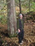
One of my favorite summer hike by Crystal Caves trail.
January 15, 2010

Nelson’s secondary watershed
(Difficulty: Intermediate) Minutes from Nelson downtown, head towards the big orange bridge (hard to miss) on to Nelson Avenue and take a right on Elwyn Street. At the top you will come to a parking area on the right and you can see the old rail road track bed. (Visiting the Kootenays for the first time, or adventuring in the unknown? I recommend to have “The Kootenays (Backroad Mapbook, 4)” handy, trails, logging roads, fishing….it’s got it all!)
The access to Fell creek and Anderson creek is somewhat limited since those two drainage are part of Nelson’s secondary watershed.
Larger Map through Google Map
The caves are located on the north side of Fell creek and more easily accessed in the summer time. The Crystal caves are the remains of an old mining prospect, crystal quartz cover part of the rock wall on the exterior of the caves. Make sure to bring a flashlight along, as the caves can be pretty dark, but relatively safe to check out. The cave is laid out in a ‘L’ shape extending to about 25m into the mountain side to a dead end.
As you look up the mountain, you should see a trail that goes pretty much straight up to the right, this trail is pretty short, but can be fairly difficult to the inexperience or young hikers. A little bit of self-orientation is needed to travel across the slope to bypass a fenced area by the water reservoir. After about 300m or 400m there will be a steep goat trail leading to Fell creek. Cross over and follow the path uphill along the south bank of the creek. (If you encounter several giant rock circles, you may have gone up Anderson creek, just back track down to the fork of the to creeks and take the south branch).
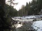
This hiking trail will take you through some steep terrain as well as a series of peaceful waterfalls. About 500m after the first crossing, there will be a flat area in the creek with the remains of crushed white quartz and a rock slide across the creek, that when you cross over to the south bank and proceed along the smaller path that follows the creek. Within about 100 to 150m, the trail become somewhat unclear and harder to travel and the caves are about 10m ahead on the left.
Happy trails! And don’t forget, a flashlight and some good hiking footwear. &8-)
-

- Nelson’s secondary watershed
-
- Hiking by Fell creek in Nelson, B.C.

-

- B.C. & Washington map

-

- One of many waterfalls along the hiking trail

-

- At the entrance of the old mine ‘Crystal caves’

-

- Inside the caves

-
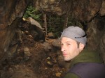
- Inside the caves, looking out!

(Visiting the Kootenays for the first time, or adventuring in the unknown? I recommend to have “The Kootenays (Backroad Mapbook, 4)
Located north of Nakusp and south of Revelstoke, these wild and undeveloped hot springs are accessible most of the year with any 2wd vehicles, although 4×4 are recommended. As winter and snow come around, snowmobiles and cross-country skis can be an attractive alternative. “Hot Springs of Western Canada: A Complete Guide” and “The Kootenays (Backroad Mapbook, 4)
” are my favorite books to pack along on my hot spring adventures.
Gps Coordinate: 50.505210,-117.784859
View Larger Map through Google Map

Natural hot springs, up the Halfway river forestry road.
Leaving from Nakusp towards Revelstoke on highway 23. Around 20km, you will see a rest area with a great waterfall indicating that you are within a couple of kilometer from the Halfway forestry road. Just before the Halfway River bridge, on the right is a logging road. Then follow the main road to kilometer-marker 10 or 11, you will find a couple of short road spurs on the left. (4wd only if you don’t care about the paint!)
Park there and follow the trail down to the river, about 300 meters. On the flats by the river, you will find 2 or 3 man-made wooden bath that can be filled to your liking with some pipes a plastic bucket to get cold water from the river, and you will need it!
View Larger Map through Google Map

Halfway Hot Springs bird-eye view
Depending on the season, some pools are built every year after the spring melt, right on the banks of the Halfway river. Pipes and rock walls can be rearranged to your liking for water temperature and size of the pool. Two out-houses have been built by generous-anonymous builders, one at the top by the parking and another one by the pools. Bringing a couple rolls of toilet paper is always an appreciated courtesy, as well as, packing all garbage out, after a nice soak. Bringing a generous amount of drinking water is always a wise move.
Happy trails! &8-)
p.s.: “Hot Springs of Western Canada: A Complete Guide” and “The Kootenays (Backroad Mapbook, 4)
” can be purchased at Amazon.com, by clicking on the title link.
-

- Natural hot springs, up the Halfway river forestry road.
-

- Halfway Hot Springs bird-eye view
-

- Sweet waterfall about 2km from the turn off.

-

- Wooden tub built by an anonymous volunteer!

-
- Hot Springs pools by the river

-

- Hot water bubbling right out of the ground!

November 3rd, Pulpit Rock trail, Nelson, B.C.
January 4, 2010

Nelson, B.C.
(View Larger Map)
(Difficulty: Easy) Nelson, British Columbia is situated in the south west part of the province. Surrounded by mountains and pristine forest, short hikes from the city limits are plentiful (as well, for avid mountain bikers). Visiting the Kootenays for the first time, or adventuring in the unknown? I recommend to have “The Kootenays (Backroad Mapbook, 4)” handy, trails, logging roads, fishing….it’s got it all!

Kootenay Lake
(View Larger Map)
Pulpit Rock has always been one of my favorite hike to introduce to Nelson’s new comers. From the trail head, it is a 45 to 60 minutes hike to Pulpit Rock with a medium incline. From downtown Nelson, you can add an additional 25 minutes to get to the trail head on foot.
To get there from downtown, head toward the lake and across our Big Orange bridge (pretty hard to miss) and take a left on Johnston rd. within about 1.5km you will come to the trail head on the right with complimentary parking.


(Visiting the Kootenays for the first time, or adventuring in the unknown? I recommend to have “The Kootenays (Backroad Mapbook, 4)” handy, trails, logging roads, fishing….it’s got it all!)
December, 28th 2008, No Boarding in Nelson, B.C. streets.
March 17, 2009
My buddy Ed and I had a blast all morning. No boarding with a little Burton snowboard (095cm to be exact) and a couple of Dakine Spike Stomp Pads
Thanks to my cellphone and Ed’s camera skills, here’s a quick edit of the day ‘youtubed’. Don’t miss the wipeouts after the credit screen. Enjoy.
Wanna try? You can order a sweet custom no board or snowskate from Jordan at http://www.thesnowskateshop.com/ and use the code [outdooradventures] for a 10% discount on your order.
